River Project Promises Clarity, Security for State Water Resources
August 29, 2012
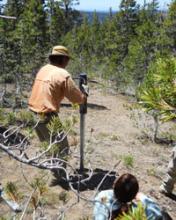 A statewide water-monitoring system is one step closer to reality as a group of UC Merced researchers install wireless sensors across the American River basin.
The sensor system is designed to give continuous information about how much water is available to users, and could go live online at the beginning of 2013.
“Our research provides a template for the next-generation water system for California,” said UC Merced lecturer and researcher Robert Rice. “We will be able to accurately know the amount of snow across the Sierra Nevada, as well as the timing and magnitude of snowmelt, which provides our water.”
The low-cost sensors in the American River basin will give scientists, water managers, farmers, flood-control managers and others a much more detailed picture of the amount of water in the basin – water that supplies much of the metro area with water for households, crops, ecosystems, power generation and recreation.
“The Sacramento Municipal Utility District is pleased that the Sierra Nevada Research Institute selected the American River Basin to evaluate this promising technology,” said principal civil engineer Dudley McFadden. “Our customer-owners expect SMUD to maximize our renewable and inexpensive hydroelectric resources. The better handle we have on the winter snowpack upstream from our storage reservoirs, the more we can rely on our forecast of summer hydropower.”
“A modern, accurate water-information system is critical for water security, especially given the changes brought about by climate warming in the mountains,” said Professor Roger Bales, director of UC Merced’s Sierra Nevada Research Institute.
Bales and colleagues developed the technology by making comprehensive water measurements in the Southern Sierra Critical Zone Observatory, near Shaver Lake.
But this is a much bigger project.
“We’re going from monitoring a 5-square-kilometer area to a 5,000-square-kilomter area in one big jump,” said engineering Professor Martha Conklin. “It’s a full-basin hydrologic observatory, and a prototype water information system.”
Rice, Bales and Conklin are just a few of the people and groups involved with the project. The California Department of Water is also involved, as is the USDA’s agricultural research station in Boise, Id., which is running a long-term hydrologic experiment of its own and helping manage this large project. The project is also part of the Intelligent Water Infrastructure initiative at the Center for Information Technology Research in the Interest of Society (CITRIS).
Hydropower interests, energy agencies, irrigation districts and other water managers, as well as groups responsible for flood management, await the stream of data that will be available through the Department of Water Resource’s California Data Exchange Center website.
The data will be available to the public, and Rice said that will give other scientists the chance to use the information for their own research.
The National Science Foundation granted $2 million for the monitoring system’s construction and placement, and the researchers plan to begin measurements this fall and have the data streaming by January, if not before.
Data gathered will include precipitation, snowmelt, snow-water content, soil-water storage and more.
Three groups of sensors are already in place, and three are being added this fall. Over the coming two years, researchers plan to place 12 to 15 more groups of sensors in the north, south and middle forks of the American River.
“This is just the next step,” Bales said. “Next, you could do the whole San Joaquin Valley, and eventually the whole state.”